

So perhaps you’ve heard on social media that there’s a Category 6 Doom-o-cane that is going to blow away your house — yes, YOUR house — next week. According to certain Social Mediaorologists, it will also untuck your shirt tag, make you lose your good cereal spoon so you’re stuck using that one you don’t like, and subscribe you to spam emails.

Let’s see if we can cut through the treacle a bit here, shall we? Here are a few facts, in no particular order:
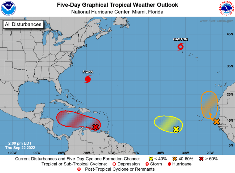
The National Hurricane Center is tracking an area that could — and it’s fair to say likely will — develop into a tropical depression, probably a tropical storm, possibly a hurricane, and maybe even a major hurricane. There is an 90% chance that it will become a tropical depression sometime in the next five days… and an 80% chance it happens by the weekend. On the map below, it’s that red X just north of South America, and the red striped area is where it could be going over the next five days. Yes, there are other things on the map, too. For purposes of this discussion, let’s ignore them for now (and maybe forever). This area is currently known as Invest 98L, but could become a named storm later — likely named “Hermine.”
The area of low pressure is currently in the southeastern Caribbean Sea, but it remains relatively disorganized. The environment where it is now is forecast to become more conducive for development, and the are where it will be by the weekend is expected to be conducive for even more development.
Because it’s currently so disorganized, forecast models aren’t quite able to accurately “latch onto it,” so they’re not yet able to provide a solid track on where the system will go or how strong it will be. This means that any forecast model you see that shows a hurricane sitting over your house 7-10 days from now is just an educated guess based on conditions at this very specific moment and those guesses change every few hours as new data comes in. Models this far in advance are notorious for being wishy-washy, with tracks moving east and west and east and west over and over and over again.

And, you get multiple models doing this — each possibly arriving at a different solution. So for every doomsday model you find targeting your home, you can probably also find a sunny day model, too.
To give you an idea of the amount of play, here is a wide range of potential outcomes right now, based on input from four different forecast models. Note the range of long-term possibilities on September 30th is everywhere from the Bay of Campeche all the way up to Maine (with Texas to Florida/South Carolina being more likely).

Exact Strength at landfall is notoriously difficult to forecast, even12-24 hours in advance, thanks in part to variables like water temperature and upwelling (churning up colder water from down below) — not to mention micro-actions such as eyewall replacement cycles that can weaken and strengthen the strongest part of the hurricane with no real advanced warning. And, as storms like Charley and Irma have shown us, last-minute changes in direction in the hours immediately before landfall can make a world of difference in impact.
Bottom line: it’s too early to know what this system will do. It’s too early to declare “it’s comin’ straight for us!” and it’s also too early to say “Definitely not our dino.” The only thing we can say right now is “we don’t know.”
We will know more by this weekend — or early next week. In the mean time, try not to panic on worst-case scenarios. We are in the peak of hurricane season, so you should already be low-key prepared for a hurricane at any time. If you haven’t already done so this season, you can and should do things to prepare for any potential storms that might arrive this year — such as buying a little extra canned/boxed food that you’ll eat anyway — but it’s not time to board up the windows.
Be aware, but you don’t need to take any major actions just yet.
Keep calm and carry on — and check back in a couple of days.
Pingback: TD 9 Forms, Could Become Major Hurricane. Attractions in the Cone. Prepare to Prepare, but Don’t Panic. – Meteottractions